Motivation
24 February 2022 marks a day, which divided the lives of millions into “before” and “after” – russia has launched its full-scale war on Ukraine. Since then, brutal attacks from land and air onto our cities haven´t stopped for a day, dozens of thousands of people have perished and those who didn´t carry stories about russia´s war crimes against humanity, such as mass murder, torture and rape of civilians. Tens of cities have been razed to the ground and hundreds of others are severely damaged, which led ten million refugees to seek a new home elsewhere, either in the West of Ukraine or abroad.
As people try to adjust to this new reality, Ukrainians all over the world are looking for the best means to help our motherland within their capabilities. Especially students and practitioners of urbanism recognize that their knowledge and effort will be needed a lot
during the next decades. I am no exception. As a case study for my master thesis project (developing a prototype of a tool for stakeholder participation in restoration processes) I have chosen Irpin – a severely damaged town in Kyiv Oblast.
Ghost Cities
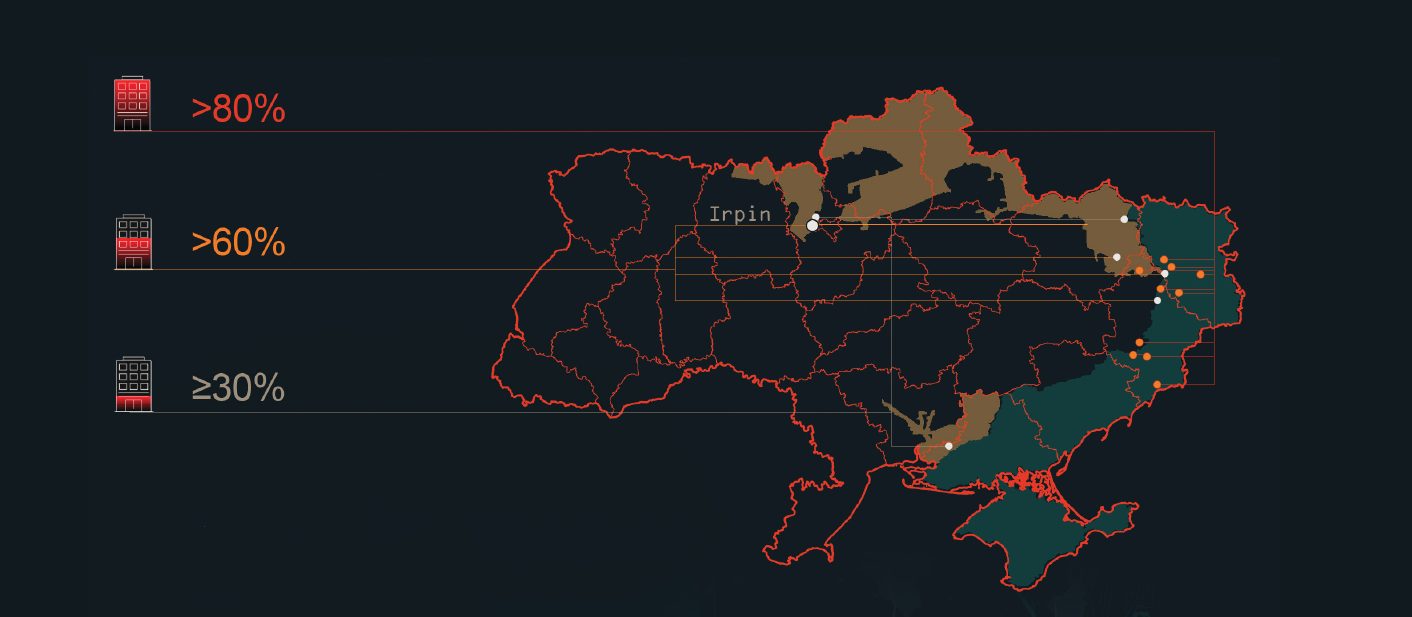
A city is called completely destroyed if the amount of destroyed buildings or buildings, which are damaged beyond repair exceeds 80%. There are ten such cities in Ukraine right now, most of which are temporarily located under russian illegal occupation. The rest of them are located on the frontline or close to it. These cities are Mariupol, Volnovakha, Vuhledar, Mariinka, Popasna, Soledar, Shchastya, Lyman, Sieverodonetsk and Rubizhne.
(Slovo i Dilo, 2023) Below, you can see them marked with orange dots (Fig.1). Inoficially, Ukrainians call them “ghost cities” or “cities, that no longer exist”.
(Occupied territories are coloured in blue, liberated ones – in yellow.)
Data Source: UNOSAT, estimates by Ukrainian authorities as of 03.02.2023
A city is called partially destroyed if the amount of destroyed buildings exceeds 30% and is less than 80%. The most evident examples are Bucha, Kupiansk (with approximately 30%), Kherson (30-40%), Lysychansk, Bakhmut, (60-70%), Izyum and Irpin (70-80%). (Slovo i Dilo, 2023)
The latter has been chosen to be my case study, because, unlike the ghost cities, it is neither under occupation, nor in the midst of the battlefield anymore. It has been liberated, so now the restoration processes in the most heavily destroyed community of Kyiv can begin.
Case Study: Irpin, Kyiv Oblast
Pre-war Irpin used to be an affordable commuter town on the outskirts of Kyiv, the Ukrainian capital. Its population amounted to 65 000 people in 2022 with a total area of 110 km2.
As of 2016, 26 industrial manufacturers are operating in the Irpin region. The city had close to one thousand enterprises of various forms of ownership, the most notable ones producing building materials and furniture. However, there is no consistent assessment of
whether or not they are still operating or if they were reestablished after the temporal occupation. There are reasons to assume that not all of them could have survived the blow from our war-mongering neighbours. A lot of businesses moved to the West of Ukraine, drastically changing the economic map of our country.
The agricultural sector of Irpin provides the capital with vegetables. In addition, the city is a popular health resort area, well known for its recreational facilities.
The Battle for Irpin
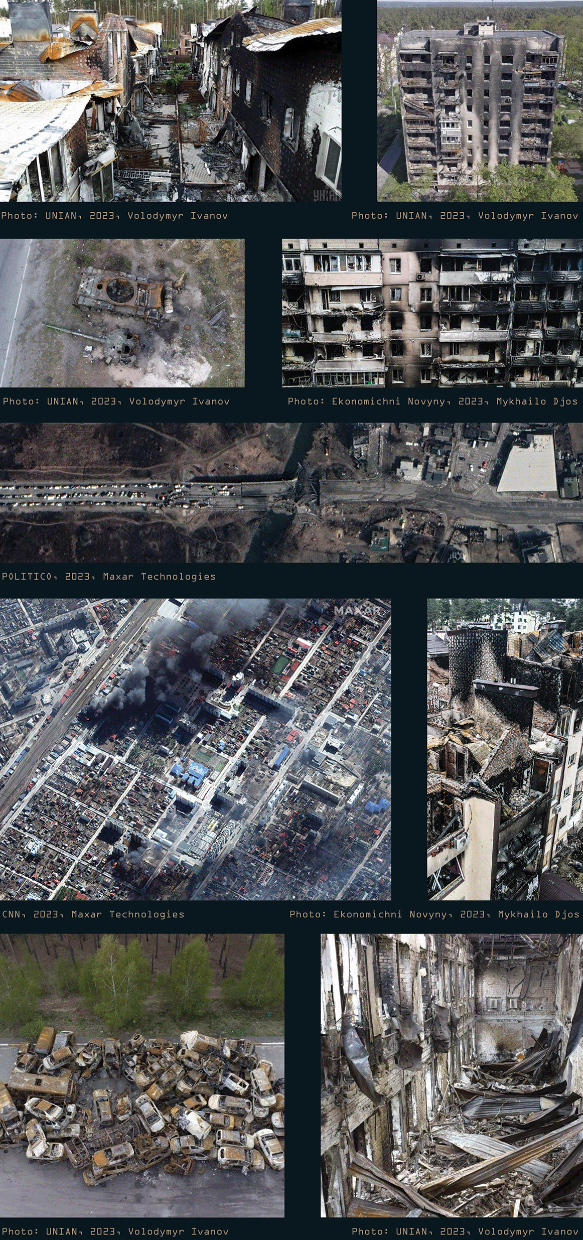
On February 27, russian ground troops broke through from Bucha towards Irpin. Tank fights broke out inside the city, and Ukrainian infantry fought with russian airborne troops. The mayor of Irpin, Oleksandr Markushyn, said that russians tried to break through the city, but were repelled by the Ukrainian Army, territorial defence troops and tank reinforcements from Bucha. Fierce fighting took place at the Zhyraf shopping centre between Bucha and Irpin. On March 2, 2022, two russian Su-25s conducted an air strike in Irpin, one of which was shot down. According to the National Police, starting from 5.03.2022, artillery shelling took place daily in the city. The Ukrainian Land Forces reported that russian troops began to lose the initiative in the offensive, suffering significant losses and stopping at “unfavourable lines.” Soldiers of the 72nd Separate Mechanized Brigade destroyed the occupiers who were trying to break through to Kyiv. As a result, the Ukrainian military pinned the invaders in a cauldron, continuing to push the enemy away from the Ukrainian capital. According to the local authorities, on March 28, Irpin and nearby towns were liberated from russian troops.
On March 24, 2022, by the Decree of the President of Ukraine to honour the heroism and resilience of citizens displayed during the repulsion of the armed aggression of the russian federation against Ukraine, Irpin was bestowed with the honorary award “Hero City of Ukraine”. Irpin paid a heavy price for not letting the enemy get to Kyiv, which preserved Ukrainian statehood. No other community in the Kyiv region has suffered such sorrow. Now Irpin has become a symbol of the destruction of Ukraine’s towns and cities.
After the liberation, evidence of numerous war crimes was in a nearby town Bucha, where russians committed unspeakable deeds to the civilian population, that didn´t manage to evacuate.
Damage assessment
As of 2 November 2023, UNESCO has verified damage to 327 sites since 24 February 2022 – 124 religious sites, 142 buildings of historical and/or artistic interest, 28 museums, 19 monuments, 13 libraries, and one Archive. (UNESCO, 2023) According to the Kyiv School of Economics, the Russian invasion has already caused at least $95.5bn in damage to Ukraine’s infrastructure as of the end of 2022. (Financial Times, 2022)
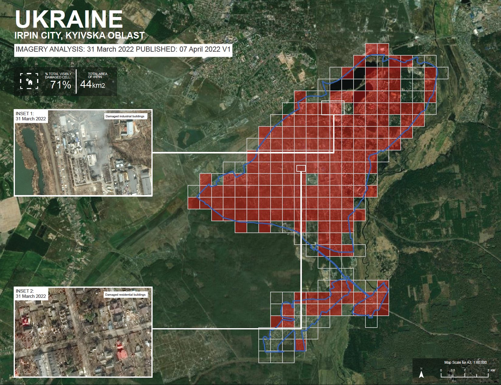
Satellite Data: WorldView-3
Copyright: © 2022 Maxar
Source: US Department of State, Humanitarian Information Unit
UNOSAT overview map illustrates a satellite imagery-based Rapid Damage Building Assessment (RDBA) in Irpin. After the division of city map into 500m x 500m cells, each of them has been analyzed to determine whether there are damaged buildings inside. Based on images collected on 31 March 2022, analysts from UNITAR (United Nations Institute for
Training and Research) and UNOSAT (United Nations Sattelite Centre) found that 176 cells out of 246 sustained visible damage. This represents approximately 71% of the cells in the city.
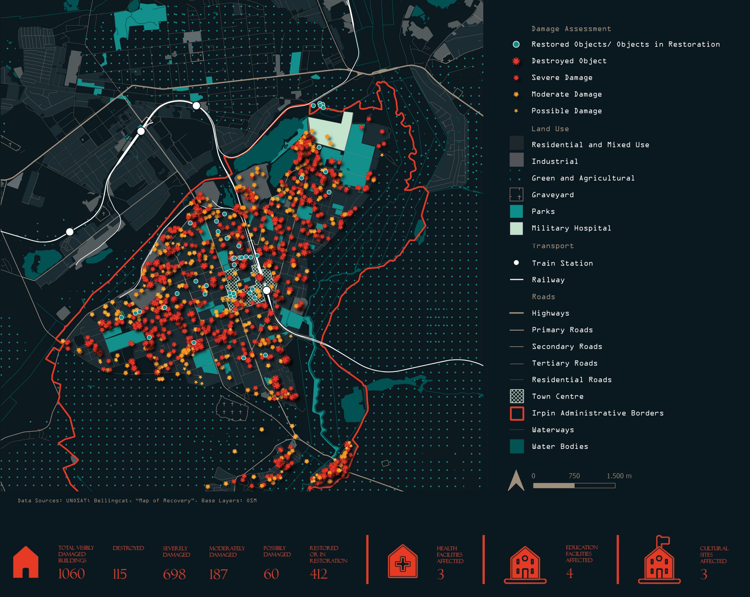
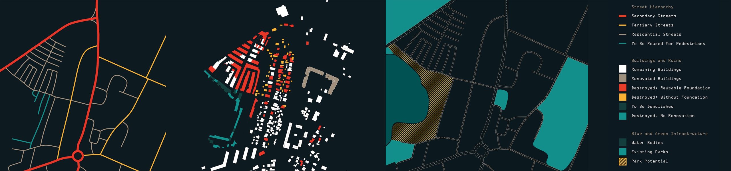
The map above is an outcome of a comprehensive analysis of damaged and restored buildings in Irpin, combining data from different sources – previously mentioned UNOSAT in addition to the Bellingcat dataset and “Map of Recovery”, a project by “Anti-Corruption headquarters”.
Rebuilding efforts
After the liberation of the occupied territories, the authorities began the process of rebuilding the city, which involved the governments of ten countries, as well as architects, volunteers, businesses, and international organizations. (Nuzhnenko, 2023)
As visible on the map above, many buildings in the city centre have already been rebuilt, however, a lot more needs to be done to return the city to its former glow. Irpin City Council also won a €7.7 million grant from the Nordic Environment Finance Corporation (NEFCO). These funds will be used to reconstruct the city’s networks. The International Committee of the Red Cross is already helping to repair damaged heating, water supply and sewage networks.
The world-renowned American architectural firm Gensler is now developing a master plan for the Irpin community. In particular, Gensler specialists organized a large-scale survey of Irpin residents about their vision of the city’s development. On its basis, Gensler has already unveiled its understanding and vision of Irpin’s development as a “garden city with a smart heart.” This plan envisages that the environment and economic growth will be prioritized.
According to the founder of the Irpin Restoration Fund, restoration of living areas is possible thanks to the cooperation of the project “Irpin Reconstruction Summit“ and an Italian fund “Terre des Hommes Italy“, as well as IOM Ukraine and Platform UNITED 24 (initiative of the president). (Volodymyr Karpliuk, 2023)
Not only reconstruction itself, but the issue of dismantling destroyed buildings, proper environmental processing of construction waste and its further use in construction is extremely important during the reconstruction of the city. The UNDP, the Japanese government, and the Lithuanian Demolition Association are providing significant assistance in this regard. This is also a rather costly process.
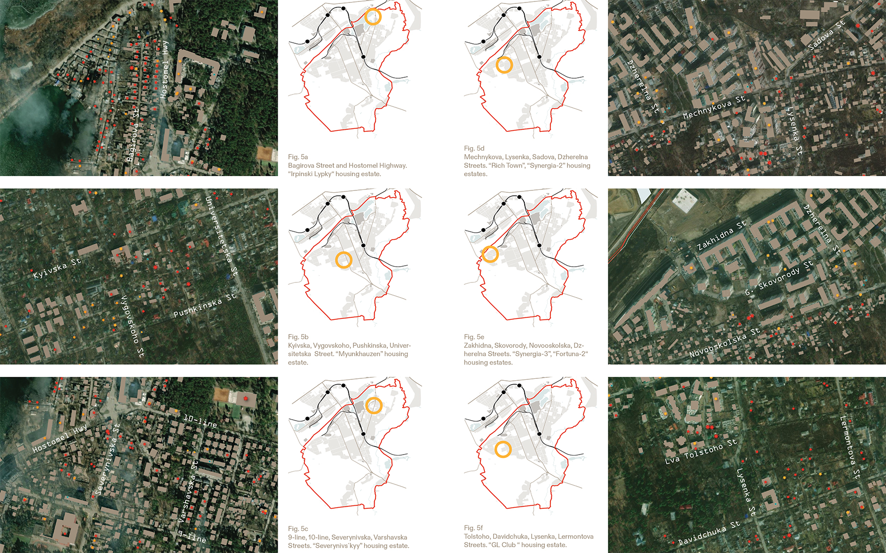
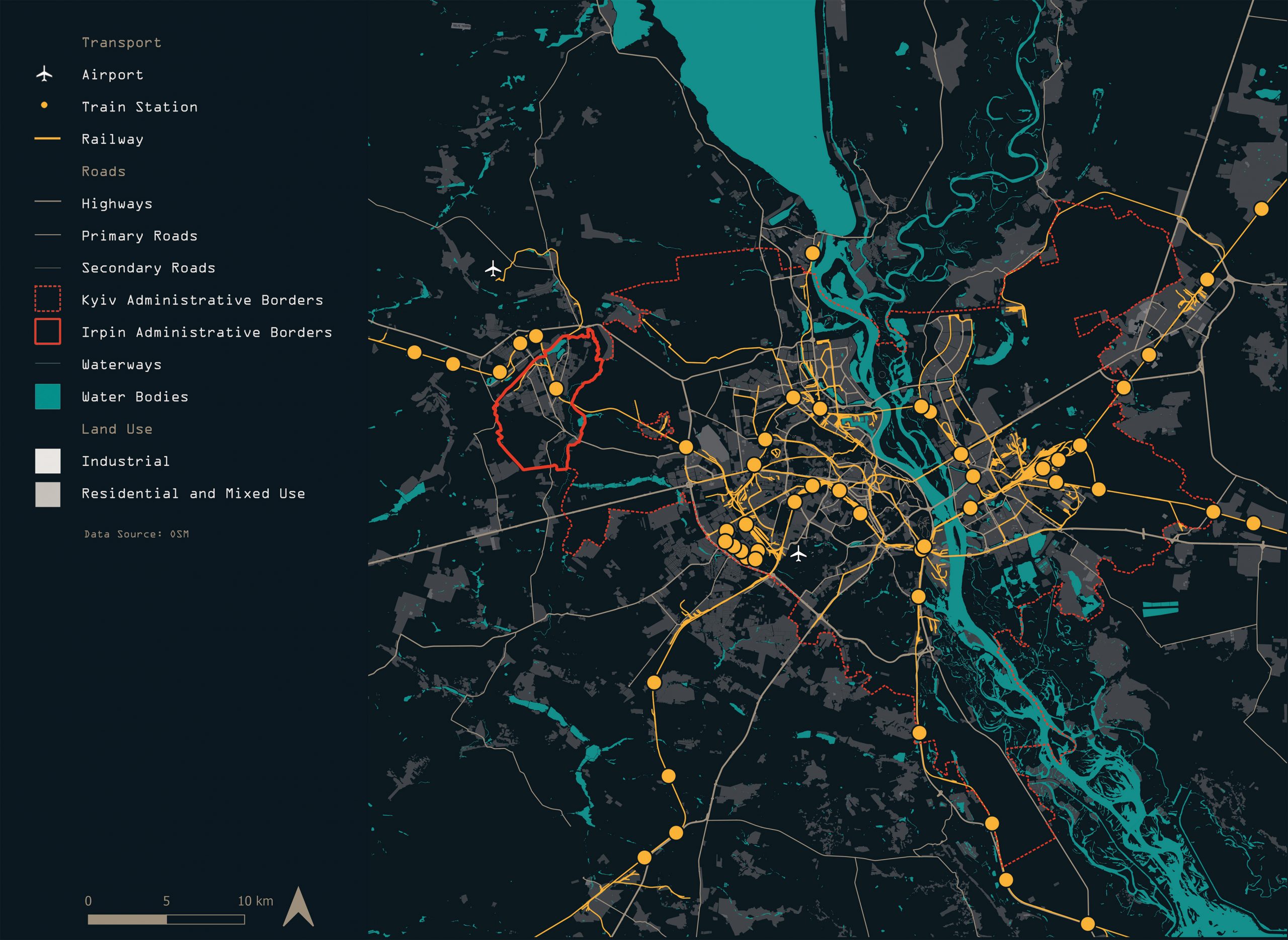
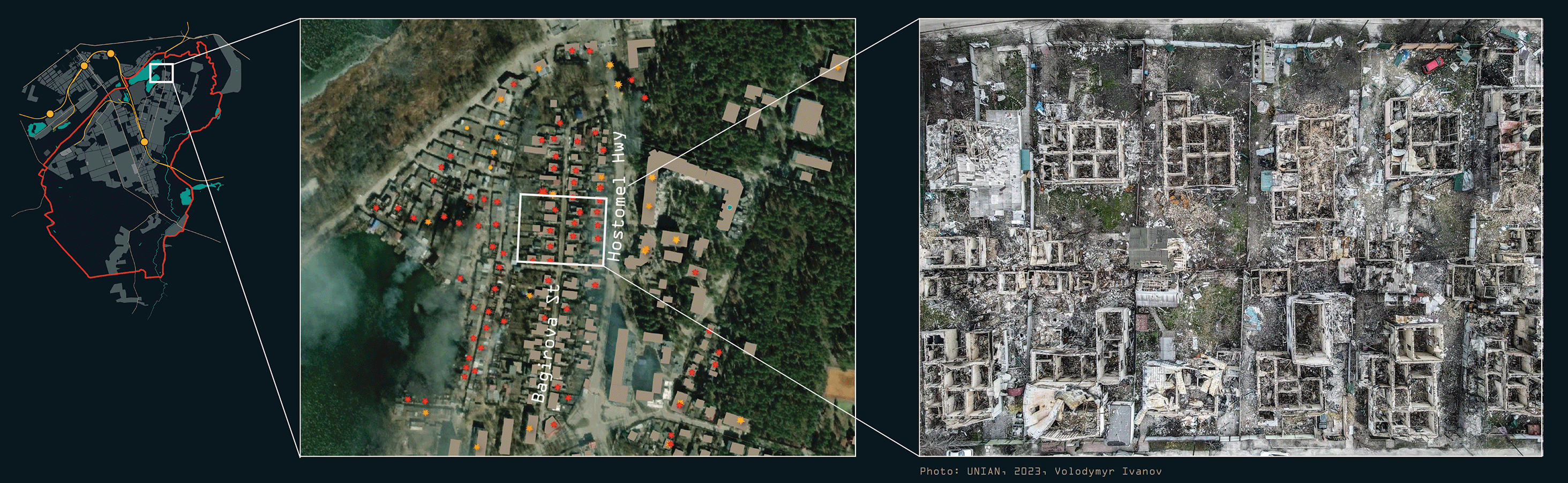
Hostomel highway and Bagirova street
As for the dismantling of private houses, the most active work is underway in the areas of Bagirova Street and Hostomel Highway. They are going to be rebuilt from scratch. This neighbourhood has suffered the most during the hostilities. (Fig. 5a) Further, I will focus on this neighbourhood.
The reconstruction started at the end of May 2023. (Baliukh, Rebuilding from 2023) It is being carried out under the program of the Kyiv Regional Military Administration and the Irpin City Council – reported the first deputy mayor of Irpin, Andriy Kravchuk (Afonina, 2023). This area will be rebuilt according to a single integrated project of the neighbourhood.
The Kyiv Regional Military Administration has allocated 60 million for this purpose.
Another UAH 140 million will be raised from the regional budget for the overhaul of the road on the Hostomel highway and the bridge. In addition, 15 million will be spent on design work and dismantling. The efforts of the state and regional budgets, as well as funds from Ukraine’s international partners, have been accumulated for these restoration processes. This is stated in the report of the Kyiv authorities with reference to the press service of the Kyiv Regional State Administration. In particular, at the request of the Kyiv City State Administration, the overhaul of apartment buildings No. 5-A, 7-A, 7-B, 22 and 24/1 on Hostomel Highway is currently underway. (3m2, 2023)
Challenges
Uncertainty
After the liberation of the northern Ukrainian territories in Kyiv, Chernihiv, Kharkiv Oblast, the refugees started returning to their homes, in many cases, only to find them destroyed or damaged (UNHCR, 2022). In Irpin, 10 000 people have lost their homes. 85% of the original population already returned, which accounts for around 55 000 people. However, it is unclear, how many more will return and when. Or will they ever come back? Two years after the beginning of the full-scale invasion, people might have already centred their life around a new job in a different city or even country.
Moreover, as the fierce fighting continues along the whole frontline in the South and East of the country, there is a constant flow of new refugees, who are seeking shelter in more fortunate areas of Ukraine or again, abroad. Every unpredictable event or shift in the frontline can result in a new refugee wave like it was after the Kakhovka dam explosion. Often these events can not be foreseen or planned and the authorities have to deal with the new challenges as they appear, spontaneously. As of 06.02.2024, Irpin has become a shelter for 25000 refugees from the East – stated Ihor Klymenko, the Minister of Internal Affairs of Ukraine (Ukrinform, 2024)
People, who have lost their homes, often choose big cities like Kyiv, Lviv and Odesa as potential new homes. No wonder, as they can offer more job perspectives and better quality of life than remote rural areas. Irpin, which has always been “a town for commuters, who work in Kyiv” can be seen as an affordable and attractive destination. There is already an influx of people from the whole Kyiv region to Irpin. Several new housing estates are being built exclusively for them. (Baliukh, 2023)
Thus, not only there is a need to deal with the city´s own demografic fluctuations, but also to be ready for a sudden increase of refugees.
Collapsing economy
War drains Ukraine´s budget and destroys infrastructure. While the main priority – to ensure Ukraine´s survival as a state – still remains, no wonder that it is very difficult to find means for other goals. Approximately 100 billion$ are needed to repair the damage from russian strikes. According to the Ministry of Finance, Ukraine’s state budget deficit for 2023 reached 1.33 trillion UAH, which is 418.9 billion UAH more than in 2022. (Ukrainska Pravda, 2024)
Needs
Flexible and rapid restoration
Considering the challenges regarding demography, the need to be ready for different scenarios is apparent. Regarding restoration processes, time is a luxury, which Ukraine does not have. Decision-making and construction must happen quickly, but in a thoughtful way.
Participation
In a country that fights for its freedom, people develop a sharpened feeling for justice. They remember why the enemy started the war – to rob us of the freedom of choice, democracy and identity. Democracy and transparency in planning processes are lived through the concept of participation on different levels and throughout every development stage. There is an increased interest in participative approach within Ukrainian communities. (Lysenko, 2018, p113.) In addition, many renowned scholars agree, that citizen participation is an integral feature of sustainable development and despite all the efforts one has to invest, it has numerous advantages when compared to top-down planning.
I appreciate the decision of Gensler (an architecture firm, that is developing a new masterplan for Irpin) to include the citizens in the decision-making process. A vision of Irpin as “a garden city with a smart heart” was based on the questionaries´ results. One can only hope that the stakeholders keep the same mindset throughout the whole process.
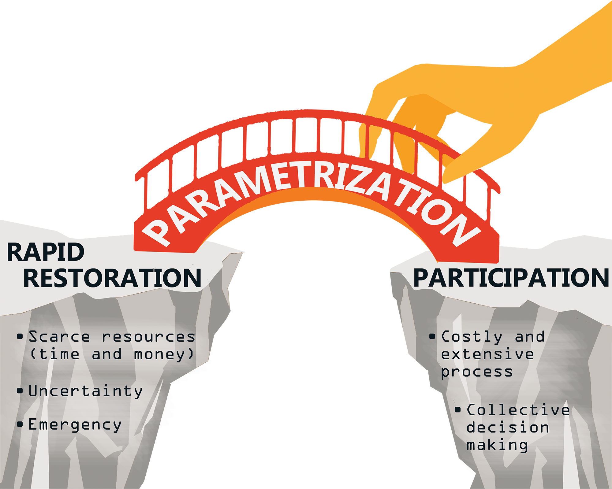
Conflict
On the one hand, the need for rapid restoration is evident. There are not enough resources (time and money) for elaborate design by expensive architects or overcomplication of processes. Like after the Second World War, residential areas have to be (re)constructed quickly and en masse. In addition, we have to be ready for a sudden rise or a drop in the demand for housing and be able to change the plans quickly.
On the other hand, if we want more democratic and transparent planning processes, which also enhance social sustainability, to build back better in the long term, planners and authorities have to take the opinions of the citizens into consideration and include them in every step of the project. The citizen participation approach is known to be more time and effort-consuming than the top-down approach, requires more complicated logistics and thorough communication between the stakeholders.
These two requirements seem not to go hand in hand. A typical participation process consists of multiple meetings, brainstorming sessions, workshops and discussions. Planners would have to think of various solutions for the site, consult the citizens and face their criticism, revisit the designs multiple times and consult the citizens again. Sometimes it might feel like a never-ending process, which a country, torn by war and faced with uncertainty, simply can not afford. If only there was an instrument, that could accelerate at least a part of such a complicated process!
Typical vs innovative visualization instruments
Status quo
A toolkit of a participation process expert includes dozens of tools for every stage of the process. For example, at the beginning, tools like advertisements and newsletters help to spread information, questionaries and interviews are appropriate tools for collecting feedback, SWOT diagrams and mapping are helpful for decision making, while typical and most common informal instruments to exchange and visualize spatial ideas include 3D models, renderings, and animations. (Pasyuta et al., 2023)
Potential
During the process of rebuilding Irpin, everyone involved should understand that we are and will be coping with uncertainties and limited resources during and after the war. Keeping these objectives in mind, one quickly comes to an understanding that under current circumstances, typical 3D models and static masterplans are outdated and inappropriate tools for exchanging and visualizing ideas.
Thanks to technological progress, it is now possible to invent new tools, which can serve us, when time is scarce. Using dynamic models, which can change “on the fly“, compared to typical 3D models that have to be manually changed every time planners want to offer the citizens a different spatial solution, could save months of precious work.
Successful practices
The plots are positioned within the development site according to the buyer´s wishes
Development site comprises of individual plots withtheir unique settings
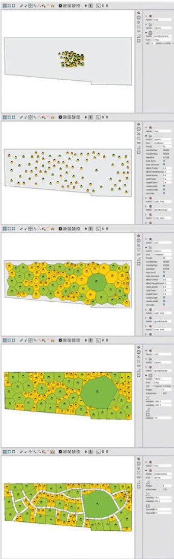
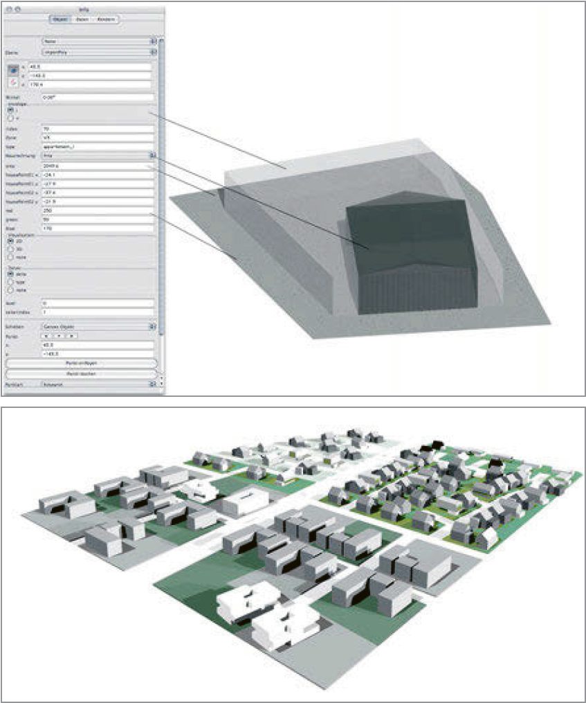
A building block is being generated according to input parameters and contextual dependencies
Parametrization is gaining popularity in every branch of industry. Recently, there have been numerous attempts to transfer this methodology to architecture and urban planning. Famous are examples by Makoto Sei Watanabe, Procedural Inc./Esri with their CityEngine, and MVRDV, who developed the Regionmaker and the Functionmixer. Leonhard Schenk offers a nice overview of those tools in his book “Designing Cities“.
The CityEngine uses parameters to generate artificial cities, that resemble the real ones. For example, a building can be given the parameter for a specific style (classic or Jugendstil etc.). Its main focus is on aesthetics.
The research network KAISERSROT was founded in 2001 as part of the DFG research project Media-Experimental Design at the University of Kaiserslautern in cooperation with the Dutch office of Kees Christiaanse Architects and Planners (KCAP). This interactive tool visualizes housing developments with the help of AI. This is a perfect example of using innovative tools for participation purposes: The parameters of the planned lots reflect the desires of their prospective residents, like the expectations about the size and proportion, the location, and the landscaping of the given plots of land.
Generative Components from Bentley graphically presents both design components and the relationships between them. It is capable of making design intent explicit, instead of only generating an approximate geometry.
Similarly to KAISERSROT, Adaptive Aechitektur from Fritz and Braach allows to set the parameters of each lot individually, independently of the superordinate planning. The entire process takes only a few minutes, so the experts moderate solutions in meetings with involved stakeholders. (Schenk, 2023, pp. 311–315)
DiGiWo, Decoding Spaces is a Rhino-Grasshopper script for building volumes generation. It emerged as a result of research cooperation between the Bauhaus University Weimar, Decoding Spaces GbR and DIPLAN (today: REHUB digitale Planer) for the semi-automatic generation of residential multi-family buildings. A user can generate variations of either an urban block or a slab typology with only minimal required guidance.
A complex multitude of rules, dependencies and constraints is the foundation of all previously mentioned tools. Each of them has its unique focus and thus follows a slightly different logic. Some are algorithm-based, while others use trained AI models. Some visualize legal constraints on the real plots, while others regulate the imaginary site from an aesthetic point of view. It is impossible to tell, which one is the best. Their inputs and expected results depend on the specific purpose of utilization of such models.
Vision
Digital solutions already help researchers and planners from renowned establishments during planning processes. No wonder, digital innovations are such a hot topic and for a good reason – they are often less time-consuming than the traditional methods. Moreover, in a country with collapsing economy like Ukraine – where time and money are scarce, but demand for restoration is huge – it is important to explore the chances, that technological progress has to offer.
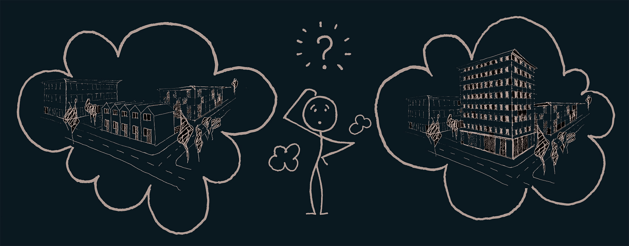
I did not intend to develop a static masterplan or design proposal for destroyed areas but rather try to create a parametric tool for easier imagination of different possible futures. A parametric model, which would help accelerate tiresome participation processes and which would enable stakeholders to better imagine possible options for the future development of urban areas. An instrument, that could be used for fast decision-making to help build back better our cities.
I set myself a goal to learn new software and develop a script, capable of generating multiple plausible spatial solutions by easily adjusting several parameters, which would stand for different tangible urban components, like building geometry and street components.
A tool that I imagine doesn´t intend to prescribe every single detail of urban space and impose the vision of the planners onto the communities. It should turn the professional knowledge of an architect or urban planner (knowledge that I gained during the years of studying) into a set of rules and limitations, which would be the basis for the script to generate controlled variety. As much as we want citizens to participate, it is important to understand that not every aspect of the built environment can be a subject of their desires. There are certain rules, building codes, that we just have to follow instead of deciding collectively. In addition, architects possess knowledge gained during long education and intuition about the matters of practicality, that comes from professional experience of observing successful examples of built structures. My vision is to embed this professional knowledge into a visual code so that it can generate many plausible solutions, from which the stakeholders then can choose. I intend to give the users freedom of choice but as a future planner, I want all the possible choices to make sense.
Watch a video tutorial and download Buildings & Streets Generator here
In the next article I also describe the logic behind my Buildings & Streets Generator (BSG).
As we proceed, let me show you now how I applied the newly developed generator to the context of Irpin.
Spatial Vision
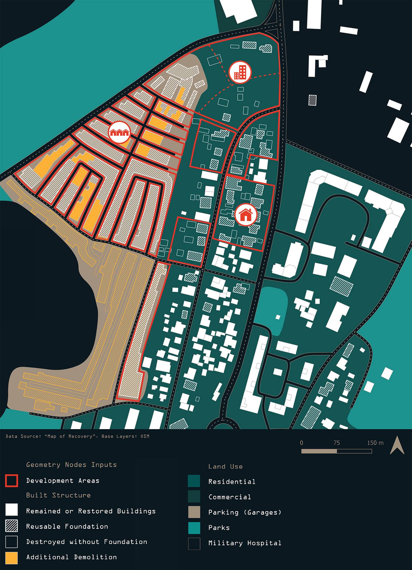
Another important observation I made is that while I can replace manual modeling of urban fabric through a script, the location and shape of development areas should rely on a general vision for a given site. In other words, while urban fabric configuration code itself is generative and universal, development areas on which the buildings are to be located might be constrained by different barriers, strengths and weaknesses of a particular site, where the code is implemented. Thus, some kind of a vision and understanding of the site´s uniqueness is necessary to give an input for the script, because it´s not capable of creating such a vision by itself. My intention for the code is to make it reusable on any site. But a vision for every site must be unique and is a prerequisite for defining development areas, which are necessary inputs for the script.
Normally, during a bottom-up planning process, stakeholders develop a spatial vision together with the guidance of planners and local authorities. As I am not a part of this process, I can only imagine what the stakeholders might want based on the preliminary results of the survey, conducted by Gensler architects. Therefore, do not take my vision as a “face value”, but rather see it as a necessary step before distributing areas for development and implementing a script, which is a main part of my thesis. After all, even if the citizen´s vision is different from mine, remember that the script can be easily adjusted to another one by changing the simple input geometry.
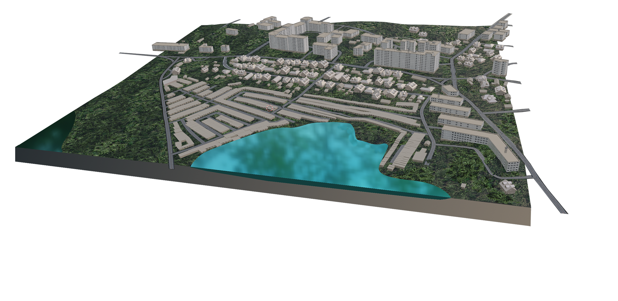
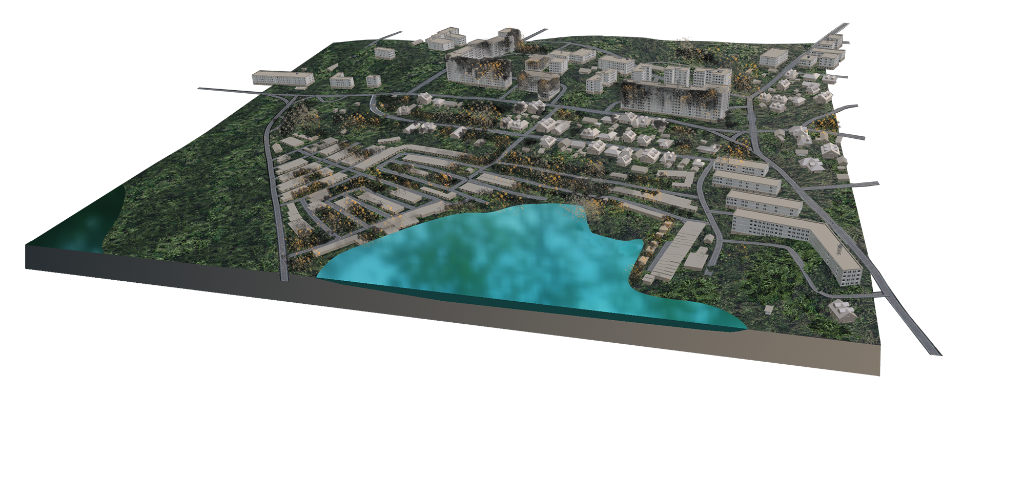
From lifeless garage landscape to green oasis
Assuming that the current and potential residents of the given site share Gensler´s general vision for Irpin as a “garden city with a smart heart“ and value green spaces of high quality, it would be a sin not to recognise wasted potential that the area around the lake has. Before the war, it was covered by long slabs, consisting of garages. Their structure almost resembles row houses, but these are solely for cars. It might sound weird to you if you come from Western Europe, but in Ukraine, it is not uncommon to see this kind of boring and monofunctional landscape.
During the battle of Irpin, many of these garages were destroyed. To avoid the same mistakes in the future, I suggest demolishing the rest of them and using this space for better purposes instead – recreation and additional residential developments. I am reserving an area around the lake for a future park. No development areas should be distributed there. This idea would fit into a narrative of garden city.
Insights that I gain at this stage, will help me define the inputs for the script. So, what other factors are there to consider?
Making use of existing resources
In a collapsing economy, when money and resources are scarce, it is reasonable and sustainable to make use of existing infrastructure, that is already on site. For example, existing foundations of destroyed buildings might be reused in order to save precious materials and construction effort.
Similarly, I assume that the road network will remain the same with minor adjustments in line with the city´s plans. Notice, that the shape of road network will have an influence on typology that can fit into space between them. For example, the parallel roads are located pretty close to each other where garages used to be. This gives us a hint, that only low houses (row or detached typology) can be used in those areas.
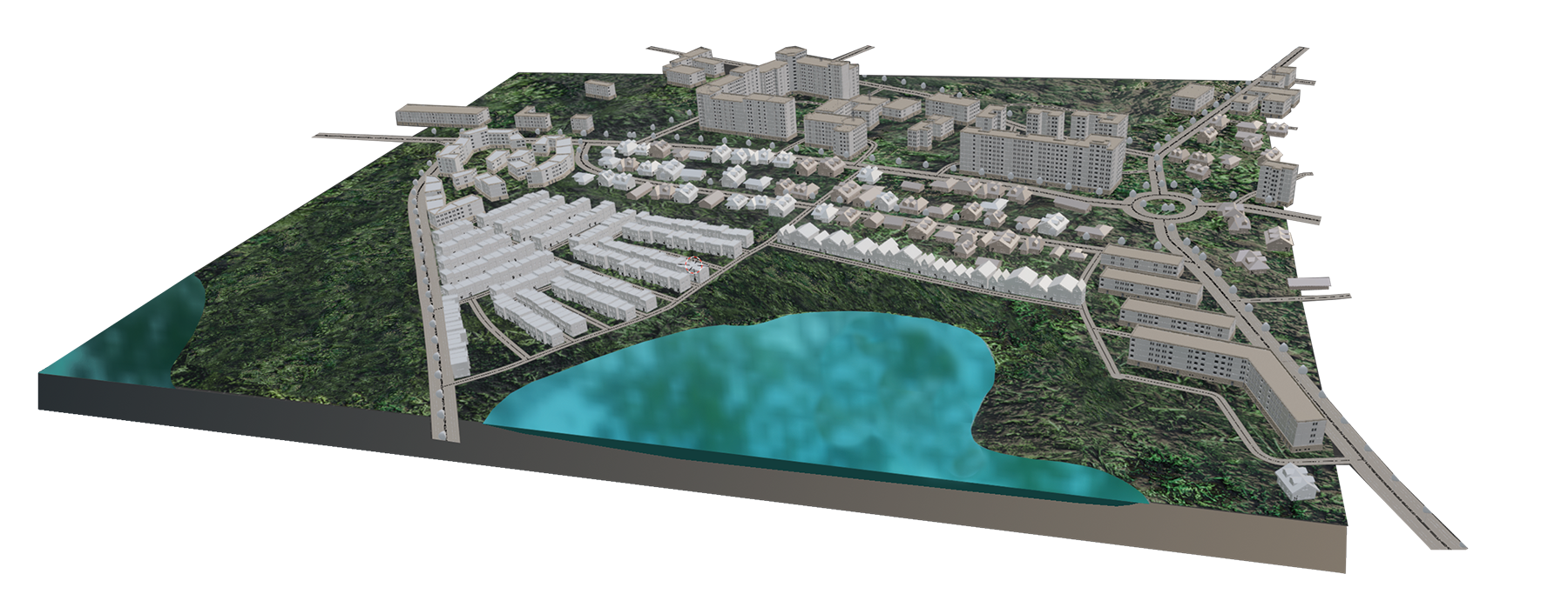
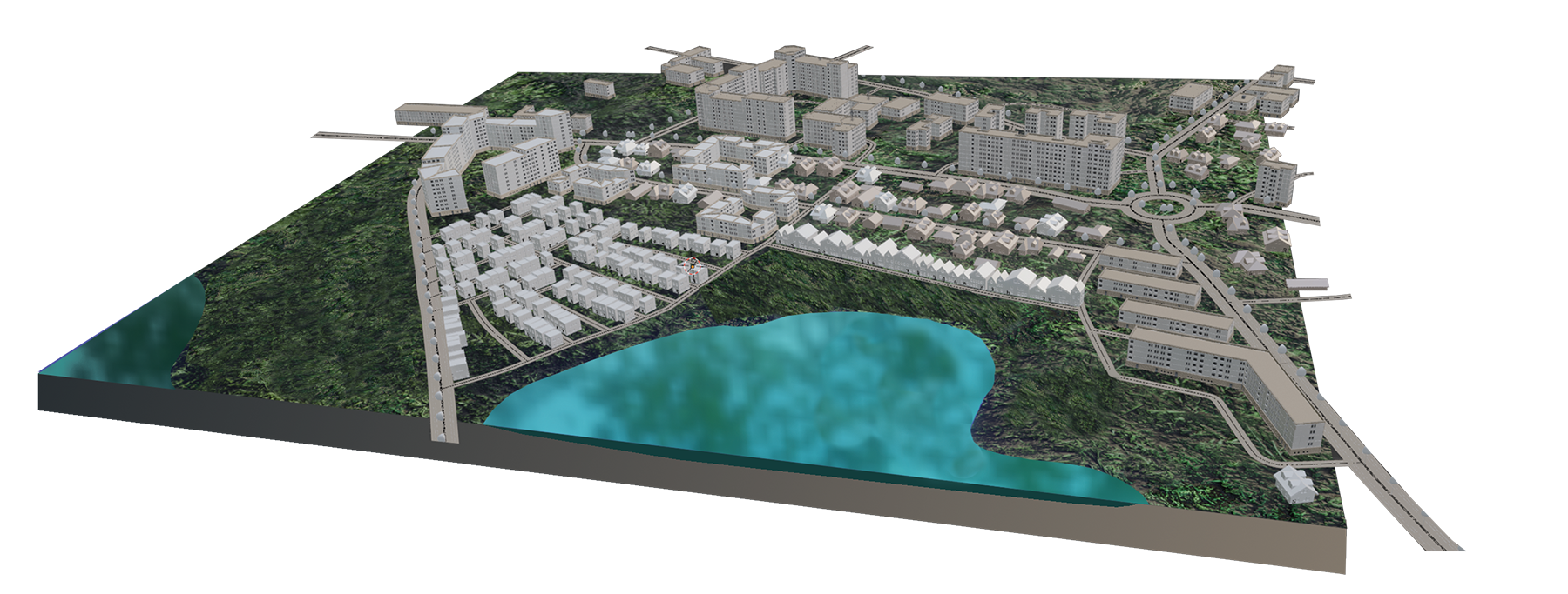
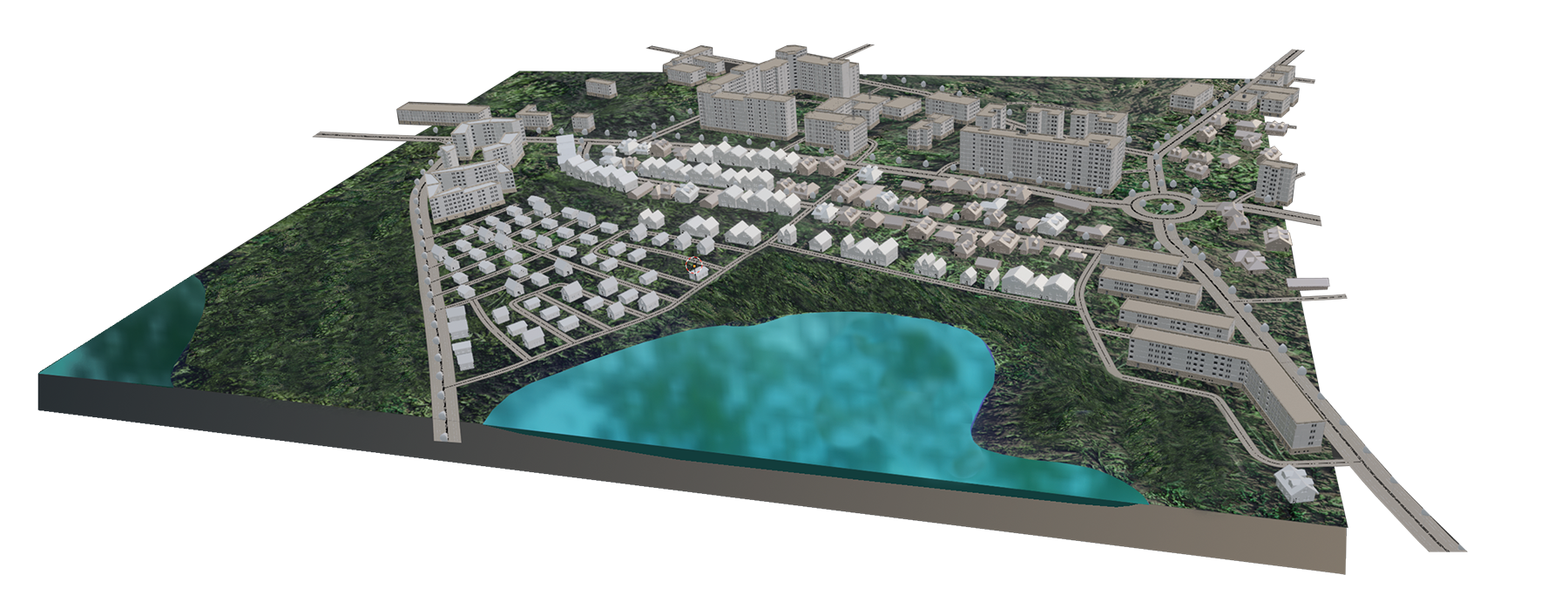
Restoration scenarios
Experimenting with a final product has been the most exciting phase of this project. I have played around with hundreds possible options for my site of interest. With the help of the developed script it is possible to generate and visualize lots of them within minutes. Here are some of my favourite ones.
Cities should be dense in the interests of urban living and sustainability, but a blend of dwelling types should be aimed for at the district and block level. (Palsson, 20, pp. 176–177) You will notice that all of these scenarios include properties of different typologies and sizes, which is probably to result in a diverse, not segregated society. It is professional
doctrine that the grain of residence by class should be fine and blurred. If one looks for equity, for communication between groups, and the ability to cross barriers, then one is led to advocate a much finer grain of residence. (Lynch, 1987, pp. 265–267)
In all scenarios, the area around the lake has been left out from reconstruction and should be preserved for recreation purposes. In addition, I provided secondary streets with tree alleys.
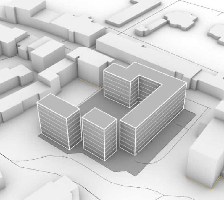
Scenario A
In this scenario, the remaining foundations of destroyed buildings are being utilized in a most efficient way. Detached houses are being rebuilt exactly how they were before the war, while row houses are being distributed in place where garages used to be.
In order to utilize garage foundations, houses of small sizes and with a maximum height of two storeys had to be chosen, because the distances between garage rows are pretty small. A development area on the northern side of the district has been further subdivided, so that three blocks could be generated.
Scenario B
This scenario can accommodate the largest number of potential residents out of the three scenarios that are shown here. Even though I provided row houses with omissions now, the overall density and number of potential residents rises drastically because of the increased usage of block typology. Large blocks can generally be said to be denser because the proportion of road area to built-up area is smaller. Conversely, smaller block sizes help boost an area’s vibrancy and porosity. (Palsson, 20, pp. 174–175) This time I didn´t
subdivide development area in the north, which allows for a height of 8-15 storeys. I find this type of block (high and wide) very appealing and suitable for the site, because they offer high densities and FAR (floor area ratio) while keeping low to moderate BCR (building
coverage ratio). Considering the fact that Irpin residents value green areas and want to perceive their city as a “garden city“, low BCR should be preferred. The top priority of urban planning is to use land sparingly. Land is a limited resource that over the centuries
has been increasingly appropriated. This fact has affected the ecological balance. (Reicher, 2016, p. 52)
Scenario C
In this scenario I allocated typologies dependent on the street hierarchy, which is reasonable,
as wider roads are needed to satisfy higher densities. The development area on the intersection of secondary roads, like in every one of these scenarios, became a ground for blocks, while row houses are aligned with the tertiary streets, while tiny detached houses can be reached via one-way residential streets.
Which scenario is your favourite one? Can´t choose? Maybe it hasn´t been visualized yet. Go ahead and experiment with the tool for yourself.
Reflexion
I would have loved to say that the script, I have worked so hard on, is universal and applicable to any context and purpose. But, as always, there are a few “buts“, that the user has to be aware of before starting to work with it. After all, it is just a digital tool, which can reduce the amount of architect´s work significantly, but it is not a magic wand.
I shaped it with a very concrete goal in mind, so, by definition, it can´t be universal, even if it is parametric. Just like the other tools, described in an abstract about successful
practices, this one is unique and has its own limited target audience.
Parametric algorithms like this can be very useful not only for participation purposes, but also expand possibilities for academic community to conduct better science.
All in all, I hope, that you will enjoy experimenting with the script and that it can be useful to other Blender enthusiasts out there!
2 replies on “Adaptable Masterplan: Damage Assessment in Irpin, Ukraine”
This is very important and useful work, thank you for your efforts
for the reason that here every material is quality based